2D Background Linework
Searching for an expert 2D background linework services?
Enhance Site Visualization with Precise 2D Background Linework Services
Obtain a transparent view of the work site with precise 2D background linework drawings. Linework gives surveyors and engineers a real-time picture of site conditions, facilitating meaningful spatial representation, informed planning and accurate data analysis. At Take Off Professionals, we offer detailed 2D mapping and linework services to support your visualization needs and drive your operations toward successful outcomes. Our team leverages advanced technology and industry expertise to transform your geographic data into usable maps supporting your project demands.
Call us at 623-323-8441 to speak directly with a member of our team.
Request A Free Quote

Understanding 2D Background Linework
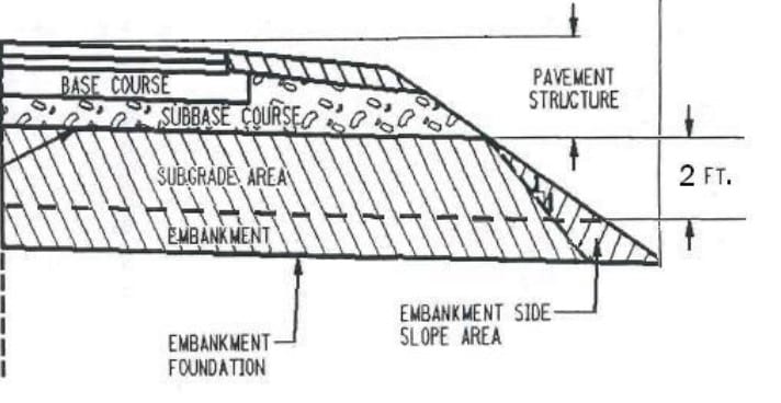
Transferring real-world features into a digital landscape is a helpful strategy to visualize your work site and optimize your decision-making tasks. Linework identifies site features, such as buildings, roads, parking spaces, underground utilities, trees and other fixtures. Generated lines are often laid over maps, plans and digital drawings, allowing us to compare accurate measurements to proposed plans and designs.
With an updated and transparent view of the job site, you’ll have the information to implement sound workflows to drive the project to a successful outcome. Obtaining detailed 2D mapping solutions is integral to a variety of industries and applications requiring detailed spatial and elevation data. Civil engineering and construction professionals rely on 2D background linework to integrate existing site features more seamlessly into their designs. Other industries that benefit from leveraging 2D background linework include:
- Telecommunications
- Utilities
- Geomatics
- Urban planning
- Land development
- Real estate
The Process of Creating 2D Background Linework
Generating meaningful linework begins with understanding your needs and project goals. To start, you should always define your project’s scope, enabling you to narrow down the data that will drive efficiency, safety, and progress. A team preparing a job site for a new building will require different information from their linework than an organization installing underground telephone lines. Once you determine your needs, you can collect the necessary data to develop an informative 2D map.
Data Collection
Most in-field tools will offer intuitive interfaces, allowing surveyors to designate feature codes to specific structures to streamline the data collection process. Unless leveraging the efficiency of a drone, most professionals traverse the site on foot to gather the necessary geographic data required to build detailed linework.
Processing
Data processing tasks will depend on access to technology and equipment. Generating linework in the field simplifies the post-processing workflow. However, those focused on collecting measurements and coordinates in the field will import their data into specialty GIS or CAD based programs to connect data points with straight lines, curves and shapes to represent boundaries and features precisely. These drawings are often laid over images and maps, enabling professionals to draw to scale and match with reference points.
Surveying software also allows for organizing and cleaning data sets to ensure unrivaled accuracy. Professionals can assign labels, attributes and annotations to provide context and clarity when sharing 2D maps with stakeholders.
Other linework creation methods include:
- Remote sensing and photogrammetry
- Importation from existing data sets
- Extraction from point clouds
Quality Control and Implementation
Before implementing 2D mapping deliverables into your decision-making workflow, you must check them for mistakes or errors. Review the linework for accuracy and completeness and address gaps or discrepancies to ensure your drawing meets your project demands. Once you confirm that it aligns with your physical site, you can incorporate the drawings into physical maps, reports, and other final deliverables. In this form, these documents will enhance your communication, analysis, and decision-making capabilities.

Ready to discuss your project?
Benefits of 2D Background Linework
Linework is a crucial step that enables surveying and engineering professionals to learn more about the spatial relationships between features and structures around their work site. While generating these lines, points and areas can take time, they have the potential to supply an assortment of meaningful advantages, such as:
- Enhancing communication: Background linework allows teams to leverage user-friendly, accessible visualizations in the context of site-specific structures, topographies, and features. These deliverables are easily sharable with stakeholders and inform progress reports to receive recommendations.
- Streamlining decision-making tasks: 2D maps simply represent complex spatial information, allowing professionals to better understand their site. You’ll have the data you need to make informed and strategic decisions to minimize mistakes and optimize the project’s success.
- Optimizing planning and design phases: A project is only as successful as its planning and design stages. 2D background linework maps provide the necessary information to identify potential challenges and make strategic changes to strengthen your designs.
- Applying data to numerous applications: Linework development is a blank canvas that can be applied to various applications. Professionals rely on this strategy to develop boundary lines, topographic lines, structural lines, reference lines and much more.
Why Choose Our 2D Background Linework Services
Take Off Professionals was founded to provide contractors with the dedicated support they deserve with detailed takeoffs. As we rapidly expanded our scope in our more than 30 years in business, we’ve developed a unique, customer-centric approach to ensure we check all your boxes. If you have specifications like preferring blue property lines over red, you can trust our team to build your data exactly the way you want it.
We can enter your project at any stage — regardless of scope or needs — and will be ready to build correct, and complete data you can trust. We strive to become your end-to-end partner, taking care of your linework creation to get you back to focusing on value-added activities.
Three Simple Steps to Begin Your Project
To get started with TOPS, you just need to follow three easy steps:
Step 1: CAD Files
Provide the CAD files for the project in formats like AutoCAD .DXF and .DWG, among others. Files can be uploaded to their FTP site or shipped with the paper plans.
Step 2: Paper Plans
If sending paper plans, they will scan and store them electronically. You can transmit the scans or ship the paper plans.
Step 3: Work Order
Fill out a data prep work order on their website with the details of your scope of work. TOPS can accommodate various needs; just specify how you want the job to look.
We have no association with any manufacturer or system type but provide 3D models for all manufacturers

Connect With Our Team for More Information
Developing intricate 2D background linework is a meaningful step in your planning and mapping projects. During site surveying, you likely collect thousands of data points describing boundary lines, topographical elements and other site features. TOPS is devoted solely to creating data-driven surveying models designed to provide unrivaled insight into site-wide conditions. We will work closely with your team to learn about your needs and devise personalized deliverables that provide your organization with valuable information.
We make getting started with our nationally recognized services more straightforward than ever. You can quickly upload your paper plans and CAD files to submit a data prep work order on our website. With these three documents, our team will get to work on your project immediately and may be able to have your data ready in as little as 48 hours. If you’re interested in taking advantage of our precision linework services, contact us online to learn more.